Are you ready to take a break from Portland’s bustling city life and explore the serene beauty of nature? Portland is surrounded by an abundance of hiking trails that offer breathtaking views, challenging terrains, and an escape into the wilderness.
I’ve lived here for three decades and have explored just about every trail there is in Portland. I’ll uncover some of the best hikes near Portland, Oregon, providing details on their length, elevation, difficulty, and what you can expect along the way. Lace up your hiking boots and let’s get started!
Hikes in Oregon Near Portland
Each trail offers its own unique experience, from breathtaking city views to peaceful forest walks. Whether you’re looking for a challenging adventure or a leisurely stroll, there’s a trail for every hiker.
** Be sure to check out my post on the Best Hikes in Oregon! **
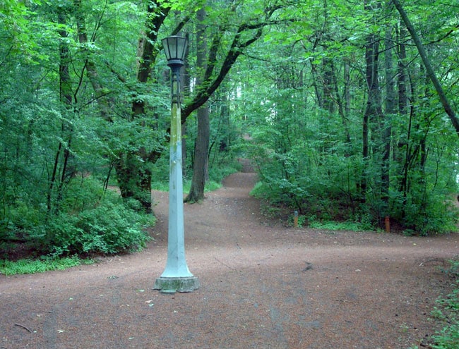
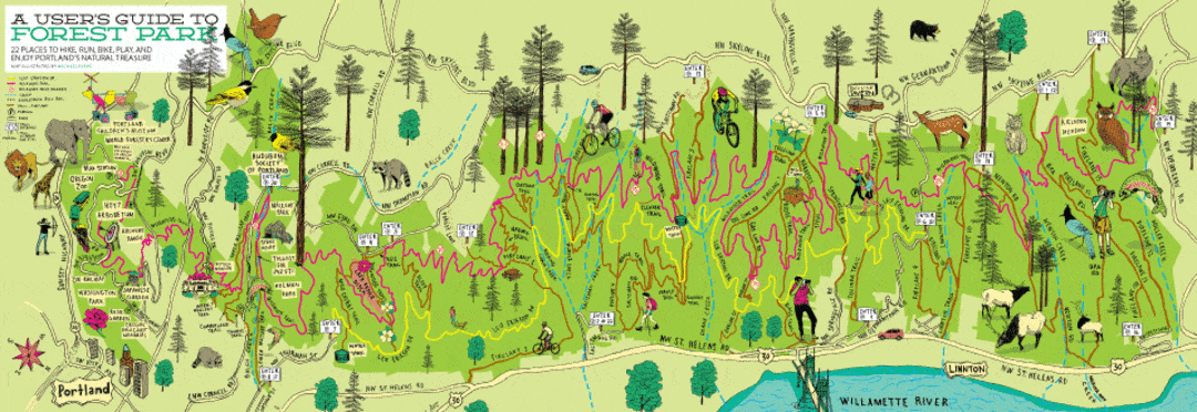
The Magic of Forest Park
Nestled in the heart of Portland, Forest Park is a must-visit for any hiking enthusiast. Spanning over 5,200 acres, it is one of the largest urban forests in the United States. With more than 80 miles of trails, including the popular Wildwood Trail, Forest Park offers a tranquil escape without having to leave the city. You’ll find yourself meandering through lush greenery, towering trees, and alongside babbling streams, making it an ideal spot for both beginners and seasoned hikers alike. Don’t forget your camera—you’re bound to encounter some stunning scenery and perhaps even some wildlife!
The first four hikes are located in Forest Park.
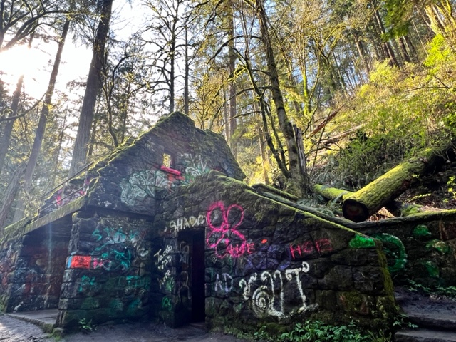
Lower Macleay to Pittock Mansion (my favorite)
The Lower Macleay to Pittock Mansion trail is approximately 5 miles round trip with an elevation gain of about 900 feet. This trail is considered moderate, making it suitable for hikers with a bit of experience but still accessible for beginners looking for a challenge.
When I lived a mere three blocks from the Lower Macleay trailhead, I would hike this trail every week. So I know it like the back of my hand.
Starting from the Lower Macleay Park, this trail takes you through lush forests and alongside the scenic Balch Creek. The highlight of this hike is the historic Pittock Mansion, which offers panoramic views of Portland and the Cascade Range. Along the way, you’ll encounter towering trees, babbling brooks, and plenty of opportunities to spot local wildlife.
This trail includes the famous Witches Castle. You can’t miss it!
The Lower Macleay to Pittock Mansion trail is conveniently located within Portland’s Forest Park. To get to the trailhead, head to the Lower Macleay Park entrance situated at NW 30th Ave and Upshur St. If you’re driving, there’s a small parking lot at the entrance, but street parking is also available nearby. For those using public transportation, you can take TriMet bus lines 15 or 77, which have stops within walking distance of the park. Once you arrive, look for the trailhead markers that will guide you onto the Lower Macleay Trail, your starting point for this invigorating and picturesque hike.
Once you reach Pittock Mansion, be sure to walk the grounds (it’s the best view of Portland in the city) and even take a tour of the historic museum.
Forest Park Ridge Trail
The Forest Park Ridge Trail stretches for about 11 miles with an elevation gain of 1,200 feet. This trail is rated as moderate to difficult, perfect for those looking for a longer and more strenuous hike.
Forest Park is one of the largest urban forests in the United States, and the Ridge Trail is the best trail that showcases its beauty. Expect dense forests, moss-covered trees, and serene silence interrupted only by the sounds of nature. The trail winds through different ecosystems, offering a peaceful retreat from the city.
The Forest Park Ridge Trail is nestled within the expansive Forest Park in Portland, Oregon. To access the trailhead, make your way to the Upper Springville Road entrance, which is at the intersection of NW Skyline Blvd and NW Springville Rd. There is limited parking available at the entrance itself, so arriving early is advisable. For those preferring public transport, TriMet bus line 50 has a stop at NW Skyline Blvd and NW Springville Rd, just a short walk from the trailhead. Follow the well-marked signs to begin your journey on the Ridge Trail, where an adventure of lush greenery and scenic views awaits.
Wildwood Trail
The Wildwood Trail is a whopping 30 miles long with varying elevation gains throughout. It ranges from easy to difficult depending on the segment you choose to hike.
As you traverse this extensive path, you’ll find yourself surrounded by towering evergreens, the scent of pine filling the air. The trail winds past picturesque streams and breathtaking viewpoints, where you can pause and take in the sweeping vistas of Portland and the Willamette River. Wildlife is abundant here; keep your eyes peeled for deer, owls, and even the occasional coyote. In spring and summer, the trail is dotted with vibrant wildflowers, making it an ideal spot for photographers and nature lovers alike.
The Wildwood Trail is situated within the expansive Forest Park in Portland, Oregon. To begin your hike on this iconic trail, head towards the trailhead located at the Upper Springville Road entrance, easily found at the intersection of NW Skyline Blvd and NW Springville Rd. Parking in this area is somewhat limited, so it’s best to arrive early to secure a spot.
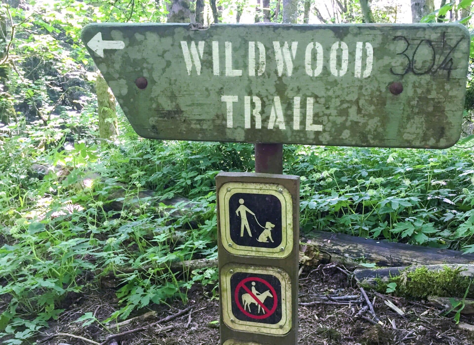
For those who prefer public transportation, TriMet bus line 50 conveniently stops at NW Skyline Blvd and NW Springville Rd, placing you just a short walk away from the trailhead. Keep an eye out for well-marked signs that will guide you to the start of your adventure on the Wildwood Trail, where the wonders of Forest Park eagerly await.
Dogwood Wild Cherry Loop Trail
This loop trail is 2.4 miles long with an elevation gain of about 500 feet, making it a relatively easy hike. It’s a great choice for families and those looking for a shorter, less demanding hike.
Located in the heart of Forest Park, the Dogwood Wild Cherry Loop offers a delightful mix of flora and fauna. You’ll walk through groves of dogwood trees and may spot wild cherry blossoms in the spring. The loop is well-marked and offers several viewpoints that provide glimpses of the surrounding forest.

To access this scenic loop, make your way to the Leif Erikson Drive Trailhead. Found at NW Thurman St and NW Leif Erikson Dr, this entrance provides ample parking options. For those opting for public transit, TriMet’s bus lines 77 and 15 will get you close, with a short walk to the trailhead from their stops. Signs marking the trailhead are easily visible, ensuring a smooth start to your picturesque journey through the enchanting Forest Park
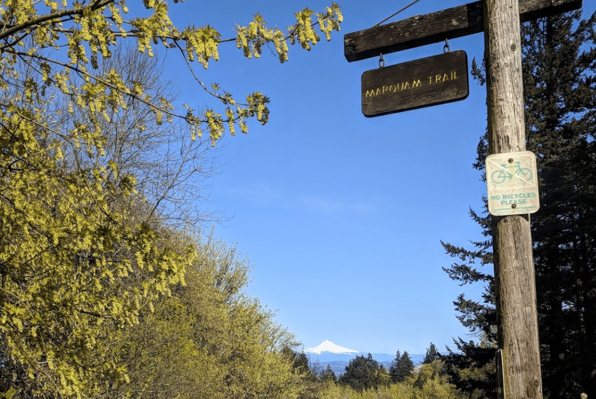
Marquam Nature Park Trail
The Marquam Nature Park Trail spans approximately 3.5 miles with an elevation gain of 600 feet. It is rated as moderate, suitable for hikers of all skill levels.
Marquam Nature Park is known for its diverse plant life and well-maintained trails. This hike takes you through dense forests, open meadows, and along tranquil streams. Keep an eye out for native birds and other wildlife as you explore the park’s natural beauty.
Marquam Nature Park is conveniently located in Southwest Portland, providing easy access for locals and visitors alike. The main trailhead can be found at the Marquam Shelter, situated off SW Marquam Hill Road. Those driving can take advantage of the small parking area adjacent to the trailhead, though spaces may be limited during peak hours.
For those utilizing public transit, TriMet bus lines, such as Line 8, provide service to stops near the park entrance. Simply follow the signs from the Marquam Shelter to begin your adventure along this scenic trail.
Council Crest Trail
The Council Crest Trail is 3.3 miles long with an elevation gain of 800 feet. It is considered a moderate hike, suitable for hikers looking for a good workout with rewarding views.
Council Crest is the highest point in Portland, and the trail leading up to it offers spectacular views of the city and beyond. On a clear day, you can see several Cascade Mountain peaks, including Mount Hood and Mount St. Helens. The trail is well-maintained and winds through beautiful forests before opening up to the summit.
The Council Crest Trail is located in the southwest hills of Portland, Oregon. To reach the trailhead, drive along SW Council Crest Drive until you reach Council Crest Park, where ample parking spaces are available. For those relying on public transportation, the TriMet bus line 51 conveniently stops near the park, allowing easy access for all adventurers. Once you arrive, simply follow the well-marked signs that will guide you to the trail’s starting point. From there, get ready to immerse yourself in a journey of stunning landscapes and invigorating climbs.
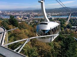
The 4T Trail
The 4T Trail is a 4.5-mile loop with an elevation gain of 1,000 feet. It is rated as moderate to difficult due to the varied terrain and the use of different transportation methods.
The 4T Trail stands for Trail, Tram, Trolley, and Train. This unique hike combines walking with a ride on Portland’s aerial tram, streetcar, and light rail. The trail portion takes you through forests and offers great views of the city. It’s an adventure that showcases the best of Portland’s urban and natural landscapes.
The 4T Trail is conveniently situated in the heart of Portland, Oregon, making it easily accessible for both locals and visitors. To start your adventure, head to the southwest part of the city. The trailhead can be found near the Oregon Health & Science University (OHSU) campus. If you’re driving, park at the parking garage adjacent to the OHSU hospital, where signs clearly mark the beginning of the trail. Alternatively, if you prefer using public transportation, you can hop on the MAX light rail to the Marquam Hill station. From there, it’s a short walk to the tram station, which marks an exciting start to your exploratory loop.
Blue Loop Trail on Mount Tabor
The Blue Loop Trail is 3.3 miles long with an elevation gain of 400 feet, making it an easy to moderate hike.
Mount Tabor is an extinct volcanic cinder cone right in the city, and the Blue Loop Trail offers an intriguing mix of natural beauty and city views. You’ll hike through wooded areas, past reservoirs, and up to viewpoints that offer stunning vistas of downtown Portland and the surrounding areas.
To get to the trailhead, you can enter the park from SE Salmon Street, SE Harrison Street, or SE Lincoln Street. Once inside the park, follow the signs to the Blue Loop Trail starting point. If you are driving, parking is available in several lots within the park, with the main lot being off SE Salmon Street. For those using public transport, take the TriMet bus routes 15 or 71 to the stops closest to the park. From there, it’s a short walk to the trailhead, where your adventure on the Blue Loop Trail begins.

Powell Butte Trail
The Powell Butte Trail is 5.8 miles long with an elevation gain of 700 feet, rated as moderate.
Powell Butte Nature Park offers a network of trails, and the Powell Butte Trail is a favorite for its diverse landscapes. You’ll experience open meadows, dense forests, and panoramic views of the Cascade Range. It’s a great spot for birdwatching and enjoying a peaceful hike close to the city.
Powell Butte Trail is situated in Powell Butte Nature Park in southeast Portland, Oregon. To reach the trailhead, you can enter the park from SE Powell Blvd or SE 162nd Ave. Upon entering, follow the signs that direct you to the Powell Butte Trail starting point. For those driving, ample parking is available at the visitor center off SE Powell Blvd. If using public transportation, take the TriMet bus route 9 to the stop closest to the park entrance. From there, it’s a short walk to the trailhead where your journey on the Powell Butte Trail begins, offering you a delightful escape into nature with minimal effort.

Eastbank Esplanade Trail
The Eastbank Esplanade Trail is a 3.5-mile loop with minimal elevation gain, making it an easy and accessible hike.
This urban trail runs along the east bank of the Willamette River, offering fantastic views of Portland’s skyline and its many bridges. It’s a great trail for a leisurely walk or bike ride, with plenty of spots to sit and enjoy the river views. The trail is paved and well-maintained, making it suitable for all ages and abilities.
You can find the Eastbank Esplanade Trail in the heart of Portland, Oregon, running alongside the picturesque Willamette River. The main access point is near the Hawthorne Bridge on the river’s east side. If you’re driving, there are several parking options nearby, including spots along SE Water Ave and the OMSI parking lot. For those preferring public transportation, take the TriMet bus route 14 or the Portland Streetcar to the stops closest to the Hawthorne Bridge. From there, it’s a short stroll to the trailhead, where you can start your easy and scenic adventure along the Eastbank Esplanade Trail.

Tryon Creek Triple Bridge Loop
The Tryon Creek Triple Bridge Loop is 2.7 miles long with an elevation gain of 400 feet, rated as easy to moderate.
Tryon Creek State Natural Area is a hidden gem in Portland, and the Triple Bridge Loop is a delightful hike through its lush forests. The trail crosses three charming bridges and offers abundant opportunities to see local wildlife. It’s a peaceful retreat that feels miles away from the city, even though it’s just a short drive from downtown.
The Tryon Creek Triple Bridge Loop is located within Tryon Creek State Natural Area in Portland, Oregon. To get to the trailhead, head to the main entrance of the park at 11321 SW Terwilliger Blvd. If you’re driving, there’s a spacious parking lot available right at the entrance. For public transportation options, TriMet bus route 39 can drop you off close to the park. From the parking lot, follow the signs to the Nature Center—an ideal starting point for your hike through the captivating scenery of the Tryon Creek Triple Bridge Loop.
Essential Hiking Tips for Portland
Hiking in Portland is an incredible way to connect with nature and enjoy the city’s scenic beauty. Here are some essential tips to make the most of your hiking adventures:
- Check the Weather: Portland weather can be unpredictable, so it’s essential to check the forecast before heading out. Dress in layers and be prepared for sudden changes.
- Wear Proper Footwear: A good pair of hiking boots or trail shoes can make all the difference. Ensure your footwear is appropriate for the trail you’ll be tackling, offering good support and traction.
- Stay Hydrated: Always carry enough water, especially on longer hikes. Hydration is key to maintaining energy levels and enjoying your outing.
- Respect Wildlife and Nature: Portland’s trails are home to various wildlife and plant species. Keep a safe distance from animals, observe without disturbing, and avoid picking flowers or damaging plants.
- Leave No Trace: Practice the Leave No Trace principles by packing out all trash, staying on marked trails, and being mindful of your impact on the environment.
- Know Your Limits: Choose trails that match your fitness level and expertise. There are options for everyone, from beginners to seasoned hikers, so pick a route that suits your abilities.
Bringing Pets on the Trails
Portland’s trails are a haven not just for humans, but for our four-legged friends too! Most of the city’s trails, including all of the trails in this post, are dog-friendly, making them perfect for a fun day out with your pup. Just be sure to keep your dog on a leash and bring plenty of water and waste bags to help keep the trails clean and enjoyable for everyone. Dogs absolutely love the natural environment, and you’ll love the added joy of experiencing the great outdoors with your furry companion by your side.
What to Pack on the Trails
Preparing for a hiking adventure involves packing the right gear to ensure a fun and safe experience. Here’s a list of must-have items to bring along:
- Water Bottle or Hydration System: Staying hydrated is absolutely crucial. Carry enough water for the duration of your hike and consider a hydration bladder for easy access.
- Trail Snacks: Fuel your adventure with high-energy snacks like nuts, dried fruit, granola bars, and jerky. These keep you energized and can be a lifesaver on longer hikes.
- Map and Compass: Even if you have a GPS device, a physical map and compass are reliable backups and can be crucial if your tech fails.
- First-Aid Kit: A compact first-aid kit is essential for handling minor injuries and emergencies on the trail. Include bandages, antiseptic wipes, and any personal medications.
- Multi-Tool or Knife: A multi-tool can come in handy for unexpected repairs, food preparation, or other needs that arise during your hike.
- Extra Layers: Weather can change quickly, especially in Portland’s diverse climate. Pack an extra layer or two, like a lightweight jacket, to stay warm and dry.
- Sun Protection: Shield yourself from the sun with a hat, sunglasses, and sunscreen. Even on cloudy days, UV rays can be harmful on exposed skin.
- Whistle: A small, loud whistle can be a great tool for signaling for help if you find yourself in trouble.


")